BEND, OR -- Despite a wet spring and a strong snowpack, experts predict Oregon is in for another hot, fire-prone summer, partly due to late spring rains. "It really drives the fuel development," says Professor John Bailey, an Oregon State University expert in forest management, "Particularly fine fuels that later on, when we dry out - we fully expect this summer, at some point, we will dry out - those fuels will cure. So the fuels will be more abundant."
He says the fire season is rooted in three things: Fuels, topography and weather. But Erica Fleishman, Director of the Oregon Climate Change Research Institute, says that triangle doesn’t take into account the preventable, "The overwhelming majority of ignitions in Oregon and across the west are human caused. They’re not from lightning."
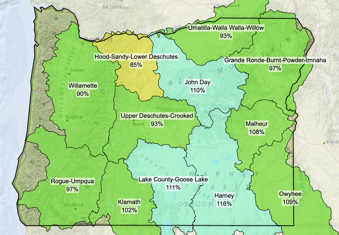
Oregon's snowpack remains strong (pictured; right), but State Climatologist Larry O’Neill believes it won't hang on for much longer and conditions will dry out quickly. He expects many basins will see below average streamflows this summer, even if the region receives typical levels of precipitation, "There will be a very sharp recession from above average flows to below average. So, if you’re into rafting and things, now’s the time to go out and get your high flows in because by the time we hit July, we’ll be below average in a lot of places." And, he says, it could hit Central Oregon especially hard, "Now that the snow is mostly melted out below 5,000 feet and it’s melting out above there as well pretty quickly, the streamflows around the area - so, the Crooked River and the John Day River system, for instance, as well as the Deschutes - we expect a significant and fast recession of those flows. Right now, they’re above average for this time of year. But we expect in the next month to six weeks, those flows will become significantly below average."
O’Neill says late winter snow, the strong snowpack and abundant spring rain - causing flooding in recent weeks - are not enough to bring the High Desert out of drought. "Since October 2019, that region [Central Oregon] has missed out on the equivalent of a full year’s worth of rain there. And what that’s left is the surface soil - so the top three to six feet of the soil column - is estimated to be the driest it’s ever been in our historical record."
Prineville Reservoir is now at capacity and Haystack is 85% full. But O’Neill says those are only small steps toward recovery, "Other reservoirs in the region - for instance, Wickiup and Crescent Lake - are still quite low for this time of year and they’re close to their lowest on record for this time of year. So, they’re not projected to refill." It all points to a potentially difficult fire season.
In the Southern Oregon Cascades, it's a very different story, where a record snowpack is melting more slowly, "And that’s basically a function of just how much snow there was this year," says O'Neill, "So that tends to push back the start of fire season a little bit." However, that could mean fire season stretches into October or November in that region.
Top Image: The U.S. Drought Monitor reflects conditions as of May 18, 2023, showing a portion of Crook County remains in Extreme Drought.


