
PORTLAND, OR -- A winter storm moving through Oregon this week brings much-needed snow to the mountains.
"Conditions will be changing this week, quite rapidly," Matt Warbritton said Monday. "It’s certainly going to get us out of sort of the trend that we’ve been in throughout December and into the start of January, where we were almost seeing close to record low snowpack, statewide." Warbritton is a Supervisory Hydrologist for NRCS-Oregon.
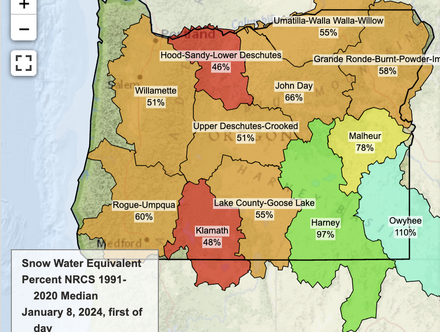
He says the snowpack was dismal coming into the new year. "Most of our sites actually, in the Central Cascades - I’m talking about generally the Santiam Pass region, between Mt Jefferson and the Sisters - Several of those sites were at record low snowpack. And in the Mt. Hood region, several sites were below 25% normal." As of Monday, snowpack in the Upper Deschutes-Crooked River Basin was just 51% of normal for this time of year (pictured). But that changes Tuesday, when the Central Cascades is predicted to get up to four feet of snow over two days. "That’s certainly going to - if that does come to fruition - provide some significant relief, in terms of the snow drought we’ve been seeing in that region," says Warbritton.
El Nino brought warmer than normal temps over the past two months, causing precipitation to fall as rain. But snow is critical for spring streamflows and summer irrigation. Warbritton says, "It’s important also for reservoir managers, because they have to manage for flooding. So, if we keep getting rain, that’s a pretty high flood risk at reservoirs that are near full."